Why Foster City
Foster City was not built up over time; it was drawn all at once. In the 1960s it was platted as a single master-planned grid on landfill in the southern San Francisco Bay, immediately east of San Mateo, wrapped around an internal lagoon and joined to the rest of the Peninsula by Hwy 92 and one internal road network. Roughly 33,000 people live inside that plan. The appeal is a contained, walkable waterfront town with its own recreation; the catch is geographic. Foster City is structurally an island, and the things a household eventually needs off the island (hospitals, high school, Caltrain) are all reached across a single bridge, which can add minutes at rush hour. Visa's global headquarters, Gilead Sciences, and Conversica anchor the in-city employer base, so many buyers work without crossing that bridge at all. Schooling is where the island shows its seams: Foster City has no K-8 district of its own, sharing San Mateo-Foster City School District (SMFCSD) with San Mateo, and it has no high school at all, sending students to Hillsdale and San Mateo HS in San Mateo, both 5 to 10 minutes off-island.
Lily has 1 documented Foster City closing: 803 Perseus Ln at $1.3M (May 2026, the most recent in the Peninsula expansion). Inside the plan, price sorts largely by how close a parcel sits to the water. Inner-tract single-family typically runs $1.3M to $1.9M; the waterfront central tracts $1.5M to $2.5M; and lagoon-front view properties with private docks $1.8M to $3.2M. Condos and townhomes run $700K to $1.4M. Per square foot, inner-tract Foster City tracks parity with neighboring San Mateo; the premium buyers pay here is for the lagoon frontage and waterfront access that the island plan created in the first place. Read that way, the Foster City housing market is one variable priced many ways, with every step closer to the lagoon adding to the number.
A short history of Foster City
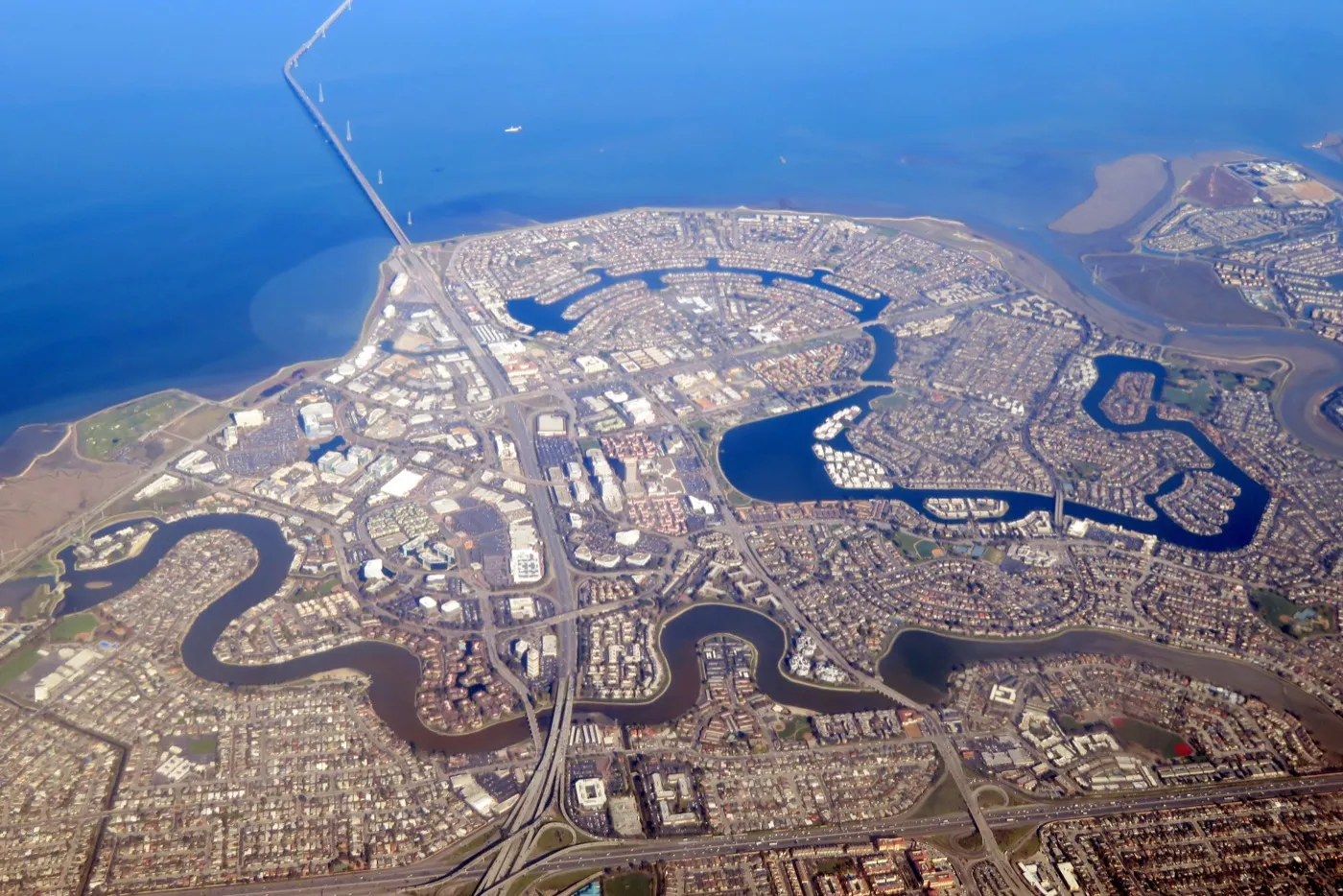
Foster City is a planned community in San Mateo County, built on Brewer Island in the marshes on the eastern edge of San Mateo and enlarged with engineered landfill. Development began in the early 1960s, and the first residents moved into the new community on March 7, 1964. The city is named after T. Jack Foster, a real estate developer who owned much of the land and helped shape its initial design. Foster City incorporated on April 27, 1971.
A defining feature of the original plan is an enclosed, man-made lagoon system of roughly 218 acres, designed to help drain the low-lying terrain. The network of waterways remains central to the layout of the city today.
Source: Wikipedia: Foster City, California.
Foster City by the numbers
A neutral demographic snapshot from the most recent U.S. Census Bureau American Community Survey. These are city-wide figures; individual neighborhoods and parcels vary.
| Measure | Value |
|---|---|
| Population | 32,964 |
| Median age | 39.7 years |
| Median household income | $193,633 |
| Homeownership rate | 51.2% |
| Median home value (owner-occupied) | $1,774,500 |
| Median gross rent (monthly) | $3,500+ |
| Average commute to work (one way) | 30.7 minutes |
| Average household size | 2.54 people |
Source: U.S. Census Bureau, American Community Survey 2019-2023 5-year estimates, Foster City city, California.
The Foster City market right now
| Median sale price | $1,500,000 |
|---|---|
| Days on market | 15 |
| Homes for sale (inventory) | 40 |
| Homes sold | 24 |
| Sale-to-list | 103% |
Data: Redfin, May 2026
For broader Bay Area context behind the Foster City numbers, read the current Bay Area market note.
What this means for you (May 2026)
With 40 available homes and 24 closings, Foster City showed fast turnover in May. At 103% of asking and a median 15 days on market, demand is steady. The limited selection means that when a home matching your criteria appears, you need to be ready. Reach out and I'll set up alerts so you see new listings the day they post.
Property taxes in Foster City
Property tax in Foster City starts with San Mateo County's 1% base under Proposition 13 (California's 1978 law capping the base rate and limiting how fast assessed value climbs), plus voter-approved bond debt. On a verified representative single-family bill for fiscal year 2025-26, the total ad valorem rate (the value-based portion) was 1.14560%, the effective rate about 1.167%.
The flat direct charges are unusually low: SMFCSD MEASURE V 2018 $357.80 and SMFCSD MEASURE B 1991 $139.50 (the San Mateo-Foster City school parcel taxes, flat per-property levies), SFBRA MEASURE AA $12.00, and SMC MOSQ ABMNT DIST $3.74, for a total of $521.08.
They stay low because Foster City sewer is billed by the Estero Municipal Improvement District, not on the tax bill, so it never appears here. See how California property tax works, and use the true monthly cost calculator to estimate a specific home. Figures come from a representative single-family county bill (FY 2025-26); every parcel differs, so check the actual bill for any home you are weighing. Compare all 38 cities side by side on the Bay Area property tax map. This is educational, not tax or legal advice; confirm any figure with a qualified tax professional and the county assessor before relying on it.
Schools (San Mateo-Foster City SD + San Mateo Union HSD)
Foster City shares San Mateo-Foster City School District (SMFCSD, K-8, 9,926 students) with San Mateo; PublicSchoolReview state rank #296 of 1,908 (top 16%). Foster City's elementary and middle schools (Audubon, Brewer Island, Foster City Elementary, Bowditch Middle) are generally among the higher-ranked schools within the district. San Mateo Union High School District (SMUHSD) handles 9-12; Foster City addresses typically feed into San Mateo HS (U.S. News #369 California) or Hillsdale HS (#424 California); some western Foster City addresses to Aragon HS (#87 California).
Foster City does not have its own K-8 district and has no in-city high school. The K-8 stack rides on SMFCSD shared with San Mateo. The high school stack rides off-island via Hwy 92 to one of the SMUHSD comprehensives. The single-bridge access pattern means the commute math for high school drop-off and pick-up is an additional structural variable buyers should weigh. Within SMFCSD, Foster City elementaries (Brewer Island, Audubon, Foster City Elementary) generally rank above the SMFCSD average; Bowditch Middle is the dominant Foster City middle feeder.
Typical assignment by sub-area
| Sub-area | Elementary feeders | Middle | High |
|---|---|---|---|
| North Foster City / central lagoon | Audubon / Brewer Island | Bowditch Middle | San Mateo High or Hillsdale High |
| Central Foster City / Edgewater | Foster City Elementary / Audubon | Bowditch Middle | Hillsdale High or San Mateo High |
| South Foster City / Marlin Cove | Brewer Island / Foster City Elementary | Bowditch Middle | Hillsdale High |
| West Foster City near Mariners Island bridge | Foster City Elementary | Bowditch Middle | Aragon High possible (verify by parcel) |
SMUHSD attendance for Foster City addresses varies between San Mateo HS, Hillsdale HS, and (less commonly) Aragon HS; the high school assignment is a meaningful pricing variable. Lily verifies the exact assignment with the SMUHSD registrar before any offer.
Highlight schools
- Bowditch Middle School (SMFCSD, 6-8), the dominant Foster City middle feeder; Niche A-rated.
- Brewer Island Elementary School (SMFCSD, K-5), one of the stronger SMFCSD elementaries; south Foster City attendance.
- Audubon Elementary School (SMFCSD, K-5), north / central Foster City attendance.
- Hillsdale High School (SMUHSD, in San Mateo, 9-12), U.S. News #424 California; the primary Foster City high school feeder.
Sources: San Mateo-Foster City SD; San Mateo Union HSD; PublicSchoolReview SMFCSD; Foster City NeighborhoodScout schools; U.S. News SMUHSD.
Hospitals and birthing centers
Foster City has no in-city hospital. The default L&D options require crossing Hwy 92 off-island: Mills-Peninsula Medical Center (Burlingame, ~10-15 min) and Sequoia Hospital (Redwood City, ~10-15 min via 92). Kaiser members go to Kaiser Redwood City (~10-15 min via 92). The island geography means a single bridge connection adds rush-hour minutes; build that into prenatal-care planning.
| Hospital | Network | Drive time from Foster City | Key services |
|---|---|---|---|
| Mills-Peninsula Medical Center (Burlingame) | Sutter (PPO) | 10-15 min | Sutter Family Birth Center; Level II NICU; the largest L&D volume facility on the central Peninsula |
| Sequoia Hospital (Redwood City) | Dignity (PPO) | 10-15 min (via 92) | Active L&D Birth Center; well-baby + special care nursery |
| Kaiser Permanente Redwood City Medical Center | Kaiser (closed) | 10-15 min (via 92) | Full Kaiser L&D (above 34 weeks); transfers premature below 34 weeks to Kaiser Santa Clara or Kaiser SF NICU |
| Lucile Packard Children's Hospital Stanford (Palo Alto) | Stanford (PPO) | 25-30 min | Level IV NICU; high-acuity referral destination |
Birthing centers: what matters
The Hwy 92 bridge dependency is the structural Foster City fact. Whichever L&D you choose, plan for a single-bridge crossing to reach it. Rush-hour Hwy 92 westbound (toward San Mateo and the Peninsula proper) can add 10 to 20 minutes; build this into your prenatal-care scheduling, particularly for late pregnancy.
Mills-Peninsula Burlingame is the default Sutter PPO L&D for most Foster City PPO buyers: Level II NICU, Sutter Family Birth Center, the largest L&D volume facility on the central Peninsula. Higher-acuity transfers go to Stanford Lucile Packard or UCSF Mission Bay.
Sequoia Hospital and Kaiser Redwood City are the via-92 south options: similar drive time, different network. Kaiser members go to Kaiser Redwood City for routine delivery above 34 weeks; premature delivery below 34 weeks transfers to Kaiser Santa Clara or Kaiser SF NICU.
Hospital network coverage depends on your insurance plan. Lily does not advise on medical coverage decisions; for in-network confirmation contact your insurer directly. Hospital information above is current as of 2026-05-28 and should be re-verified with each hospital's admissions office before relying on it for a major life decision.
Sources: Mills-Peninsula Burlingame; Sequoia Hospital; Kaiser Redwood City L&D; Lucile Packard NICU; California Perinatal Quality Care Collaborative NICU Directory.
Crime, hazards, and ratings
Foster City carries a clean crime grade and currently sits in FEMA Zone X behind an accredited levee, but the entire city is built on hydraulic-fill bay mud over what was tidal marsh. Buyers see "no flood insurance required" without realizing the seismic liquefaction exposure underneath, which is Very High city-wide. The San Andreas Fault sits roughly six miles west.
| Category | Rating | Detail |
|---|---|---|
| Crime | among the lowest crime rates in California; both property and violent crime well below US average | |
| Flood | Designated Zone X behind the FEMA-accredited levee system (the entire city is built on bay fill, but the levee provides 1% annual-chance protection). Mandatory flood insurance not required; FEMA still recommends voluntary policies | |
| Fire | Not in LRA fire hazard zones; flat island city | |
| Earthquake | liquefaction: Very High; the entire city is hydraulic-fill bay mud and is among the highest-liquefaction-susceptibility tracts in San Mateo County; nearest faults: San Andreas Fault about 6 miles west; Hayward Fault about 14 miles east |
School ratings
Numeric snapshots for the highlight schools above:
| School | GreatSchools | Niche |
|---|---|---|
| San Mateo High | 8 | A |
| Aragon High | 10 | A+ |
| Bowditch Middle | 9 | A |
| Foster City Elementary | 9 | A |
Environment and infrastructure
Beyond the natural-hazard ratings above, these are the environmental and infrastructure factors buyers ask about most. Each is a city-level summary; confirm the exact parcel before any offer.
| Factor | Detail |
|---|---|
| Gas transmission pipelines | PG&E gas transmission lines (the Milpitas-to-San Francisco Peninsula system that includes Line 132, which ruptured at San Bruno in 2010) serve the area; Foster City is a master-planned community fed by regional transmission and local distribution. Per-address proximity should be verified on the PHMSA NPMS Public Viewer. |
| Noise (freeway, rail, flight paths) | Foster City sits beneath SFO arrival/departure corridors and on the bay side of US-101 and the CA-92 / San Mateo Bridge approach; SFO and NextGen flight-path noise has been a prominent local issue, with Foster City active in the SFO Roundtable. |
| Refineries and heavy industry | No refineries or heavy industry; Foster City is a planned residential/commercial community with no major stationary industrial emitter. |
| Soil and groundwater contamination | Foster City was built in the 1960s on dredged bay fill (former Brewer Island salt marsh); the primary environmental story is engineered fill and the levee/lagoon system rather than a named Superfund site. Routine GeoTracker/EnviroStor parcels may exist; confirm specifics in state databases. |
| Air quality and wildfire smoke | Generally good regional air quality (open bay exposure aids dispersion); localized burden from US-101 / CA-92 and seasonal wildfire smoke. No major industrial emitter. |
| Wildfire zone and power shutoffs (PSPS) | Foster City is entirely flat, low-lying bay fill and is not in any CAL FIRE high fire hazard zone; PSPS/wildfire exposure is essentially nil. |
| High-voltage power lines | Local distribution and regional transmission serve the city; no single notorious residential high-voltage corridor is documented in this research. Verify per address. |
| Sea level and shoreline flooding | Foster City is one of the most sea-level-rise-exposed communities in the Bay Area: built entirely on bay fill below or near sea level and protected by a perimeter levee system, which the city has been raising/upgrading (the Foster City Levee Improvements / Protection Program) specifically to maintain FEMA flood-protection certification against rising seas. |
These are city-level summaries from public agencies and are approximate. Pipeline and power-line alignments, contamination parcels, and wildfire zones can differ block by block; verify the exact address with the agency tools linked above and your inspections before you write an offer.
Sources: PHMSA National Pipeline Mapping System; DTSC EnviroStor; State Water Board GeoTracker; EPA Superfund; BAAQMD air data; CAL FIRE Fire Hazard Severity Zones; PG&E PSPS maps; NOAA Sea Level Rise Viewer
Hazard ratings are city-level aggregates from public agencies (FEMA, CAL FIRE, USGS). Specific addresses can carry materially different risk; verify the exact parcel via the FEMA Flood Map Service Center, the CAL FIRE FHSZ viewer, and your insurance carrier before any offer. School ratings vary by year and by metric; the numbers above are point-in-time snapshots, treat them as a starting point and re-verify with the district registrar.
Sources: CrimeGrade.org (crime); FEMA Flood Map Service Center (flood); CAL FIRE FHSZ viewer (fire); USGS earthquake hazards (earthquake); GreatSchools + Niche (school ratings).
Track Record
1 documented Foster City closing, $1.3M local volume. Career-wide: 104 documented closings, $115M+ in total volume, with 91 of 104 on the buyer side, 10 closings in the last 12 months, career range $323K to $3.3M, 5.0-star Zillow average across 38+ reviews. The full transaction record for every Bay Area city Lily has closed in is summarized at the cities index.
Ready to talk about Foster City? Call or text me at 415-910-3958 for a free 30-minute consultation.
104 transactions · $115M+ · 5.0★ Zillow · Cal DRE #02010731
What buying a home in Foster City actually involves
Same fiduciary discipline as on every Lily Garipova representation: read every disclosure end-to-end, model the carrying cost (mortgage + property tax + HOA + insurance), walk the property at multiple times of day, and stay willing to walk you away from a property that does not pencil. Foster City-specific particulars are covered in the FAQ below; the SMUHSD high school assignment by address (San Mateo HS vs Hillsdale HS, occasionally Aragon HS) and the Hwy 92 bridge commute math are the two highest-leverage pre-offer factors for buyers.
What selling a home in Foster City involves
Strategic Listing Model applied to Foster City: data-driven comp analysis of the specific Foster City sub-area (inner-tract vs lagoon-front with private dock vs waterfront / Edgewater is a $500K to $1.5M price-spread per comparable square footage, with the lagoon-front view properties at the top), pre-listing prep with positive-ROI improvements only, professional staging targeted to the Visa / Gilead / tech-buyer demographic, multi-platform marketing with active bid management, and honest disclosure of every defect.
The Meticulous Protector, applied to Foster City
The methodology behind Lily's 38+ five-star Zillow reviews and strong repeat-and-referral business: read every disclosure line, verify every claim, model every carrying cost, walk every property in person before recommending an offer, document the ethical "no" when the math says no. The Foster City version of that methodology is the same as the Dublin version, the Pleasanton version, the Walnut Creek version, and every other city Lily represents, discipline does not change by city.
Foster City FAQ
What are Foster City price ranges in 2026?
Foster City single-family typically runs $1.5M to $2.5M in the waterfront central tracts, $1.8M to $3.2M in the lagoon-front view properties with private docks, and $1.3M to $1.9M in the inner-tract single-family. Condos and townhomes run $700K to $1.4M. The May 2026 Perseus Ln closing at $1.3M is representative of the inner-tract single-family band.
Foster City vs San Mateo vs Belmont?
Foster City and San Mateo share the SMFCSD K-8 district and the SMUHSD high school district, but Foster City is structurally an island via Hwy 92 with the master-planned 1960s waterfront geometry, lagoon access, and the Visa / Gilead employer base. San Mateo is more topographically and architecturally diverse with the downtown 3rd Avenue walkable core and broader Aragon / Hillsdale / San Mateo HS school options. Belmont is the BRSSD + Carlmont stack to the south; comparable pricing to inner-tract Foster City, premium over inner-tract for Carlmont attendance.
Is the island geography a problem?
It depends on how you weigh access vs lifestyle. The single-bridge Hwy 92 dependency adds rush-hour minutes to the off-island commute (to high school, hospitals, Caltrain). Conversely, Foster City's master-planned street grid, lagoon-front parks, and contained 33,000-person population deliver a quality-of-life advantage that doesn't show up in commute math. Plan for the bridge crossing in any time-sensitive scheduling (school pickup, prenatal appointments, hospital trips).
Does Lily Garipova speak Russian for Foster City transactions?
Yes. Russian is Lily's native language. Lily represents Russian-speaking buyers and sellers in Foster City and the broader mid-Peninsula in either English or Russian. Russian-language Foster City page: lilygaripova.com/ru/foster-city-realtor/.
Which Foster City neighborhood has private dock access to the lagoon?
Lagoon-front blocks with private dock rights are concentrated in Marlin Cove (south), Mariner's Island (west by the Hwy 92 bridge approach), and the perimeter lots of Edgewater along the deep-water channels. Inner-tract streets do not carry dock rights even if the parcel borders a finger of water; verify dock title and any associated Foster City Estates Owners Association covenants in the preliminary title report. The dock premium over comparable inner-tract single-family typically runs $400K to $900K depending on slip depth and view.
What does Foster City's master-planned grid mean for buyers?
Foster City was platted in the 1960s as a single integrated waterfront subdivision by T. Jack Foster on filled tidal lagoon. The result is uniform 5,000 to 7,500 square foot lots, curvilinear streets organized around the central lagoon, no through-traffic in residential pockets, and consistent setback rules. Resale comp sets are unusually clean because the housing stock is internally consistent; the spread is driven by waterfront access, school feeder, and renovation level rather than era of construction. The whole city is also walkable in a way most postwar Peninsula tracts are not.
How does Foster City Lagoon recreation affect property values?
Foster City Lagoon is the 200-acre internal saltwater body that defines the city's recreational identity: sailing, kayaking, paddleboarding, the annual 4th of July fireworks barge. Lagoon-front parcels carry a documented premium; access blocks within a 5-minute walk of a public lagoon park (Leo J. Ryan, Boothbay, Erckenbrack) carry a smaller premium. The city operates a permitted Boat Launch and the Foster City Marina has limited transient slips. Lily Garipova reviews lagoon access, HOA dock allotments, and Foster City Estates covenants before any waterfront offer.
What's the deal with Foster City's sea-level rise and levee district?
The entire city sits behind a FEMA-accredited levee system maintained by the Foster City Estates Owners Association and the City levee district. The 2020 levee improvement project raised the perimeter by three feet to maintain Zone X (no mandatory flood insurance) status through approximately 2050 sea-level projections. Properties pay an annual levee assessment (currently a few hundred dollars per parcel) that flows through with the home. Disclosure of the levee district and the AB1366 sea-level rise notice is mandatory and must be reviewed before offer. The FEMA Zone X status can change with reaccreditation cycles.
Why doesn't Foster City have a high school?
Foster City was platted in the 1960s without a high school site because the master plan piggybacked on San Mateo Union High School District's existing capacity at San Mateo, Hillsdale, and Aragon HS. Foster City students cross Hwy 92 to whichever SMUHSD high school they are assigned, typically Hillsdale (closest, 5 minutes off-island) or San Mateo HS, occasionally Aragon for the far west addresses near Mariners Island. The off-island high school commute is the most-cited Foster City trade-off for buyers prioritizing school assignment; ride-share networks, parent carpools, and SamTrans serve the daily flow.
Bowditch Middle School: what makes it the Foster City flagship?
Bowditch Middle (SMFCSD, grades 6-8, ~990 students) is the dominant Foster City middle school feeder, Niche A-rated, GreatSchools 9. Strong CAASPP performance, deep elective catalog (orchestra, robotics, journalism, multiple world languages), and a feeder pattern from Brewer Island, Audubon, and Foster City Elementary that delivers a uniformly college-prep ready 9th-grade class to SMUHSD. The school's reputation is the single biggest reason Foster City inner-tract carries the price floor it does despite no in-city high school.
How does the Visa, Gilead, Conversica employer base affect Foster City pricing?
Visa's global headquarters at Metro Center, Gilead Sciences' campus on Lakeside Drive, and Conversica anchor a tech-and-biotech employer base whose mid-career employees frequently buy in Foster City as primary residence. The result: cash-heavy offers, low days-on-market on well-priced single-family, and a steady RSU-based qualification profile that lenders are familiar with. Spillover demand from Meta, Stripe, and other Hwy 101 employers (3rd Avenue to Foster City is 5 minutes) adds depth. The buyer pool is thinner than San Jose but the willingness to pay per square foot is comparable to Sunnyvale.
Can I commute from Foster City to Caltrain without driving across Hwy 92?
Not directly. The nearest Caltrain stations are Hillsdale (San Mateo, 5-10 minutes off-island via Hwy 92) and Belmont (10-15 minutes via 92 + 101). The City of Foster City contracts a Hillsdale Shuttle that runs commute-peak service from select Foster City stops to Hillsdale Caltrain free of charge. The Bay Trail also gives a continuous bike-only route across the Hillsdale Boulevard bridge into San Mateo's Bay Meadows / Hillsdale walkshed. Most regular Caltrain commuters drive to Hillsdale and park; the city does not have a dedicated transit station.
Does Foster City have HOA neighborhoods or single-family with no HOA?
Most Foster City single-family is non-HOA but every parcel is subject to the Foster City Estates Owners Association master deed restrictions (architectural review for any exterior change, dock and lagoon access rules, levee assessment). Townhomes and condos around Edgewater, Pilgrim, Sand Cove, and Beach Park Plaza carry their own HOAs with monthly dues that vary by building and cover common areas, exterior insurance, and reserves; pull the HOA package for the current dues before an offer. Pull the FCEOA covenants and any sub-HOA reserve study, plus 12 months of meeting minutes, before contingency removal.
What is the Edgewater Foster City sub-area?
Edgewater is the southwest waterfront sub-area of Foster City, fronting both the lagoon and the outer Bay, with the Edgewater Pilgrim Triton mixed-use complex and Edgewater Place shopping center as the commercial anchors. Single-family ranges $1.6M to $2.8M; lagoon-front with private dock pushes into the $2.5M to $3.5M band. Walkable to lagoon parks, Edgewater Place groceries, and the Belmont Slough trailhead. The development era is 1970s to 1980s; mechanicals tend to be one generation newer than Mariner's Island or central Foster City.
What is Mariner's Island in Foster City?
Mariner's Island is the west-Foster-City peninsula immediately south of the Hwy 92 bridge approach, bounded by Belmont Slough and Belmont Channel. Mostly single-family from the 1970s to mid-1980s with some lagoon-front parcels carrying dock rights. Pricing typically $1.7M to $2.5M for non-waterfront, $2.5M to $3.5M for lagoon-front with dock. Some western Mariner's Island addresses route to Aragon High School rather than Hillsdale within SMUHSD (San Mateo Union High School District). Attendance assignment is set by parcel and third-party rankings differ by school, so verify the exact assignment with the district registrar before an offer.
Marlin Cove condos and townhomes, what should I know?
Marlin Cove is the south Foster City townhome and condo enclave with direct lagoon access. Two-bedroom townhomes typically $850K to $1.2M; three-bedroom $1.1M to $1.4M. HOA dues vary by unit and cover exterior insurance, lagoon dock allotment, common-area landscaping, and pool; pull the HOA package for the current dues before an offer. SB326 inspection status is the dominant variable; the 1970s wood-frame construction has been the subject of recent reserve and assessment updates. Always pull the SB326 report, reserve study, and last 12 months of meeting minutes before offer.
How does the FEMA Zone X behind the levee work for insurance?
Foster City currently sits in FEMA Zone X (minimal flood hazard) thanks to the accredited levee system. Mortgage lenders do not require flood insurance and most homeowner policies bundle a reasonable coverage limit. However: the levee accreditation must be renewed periodically, and a future Zone X downgrade (to a Special Flood Hazard Area such as Zone A or Zone AE) would trigger mandatory flood insurance; the cost varies by parcel and elevation, so get an actual quote from your insurance carrier. FEMA still recommends voluntary policies because the Zone X designation does not mean zero risk, only sub-1% annual chance. Confirm the current FEMA flood map effective date with your insurance carrier before commit.
What's the liquefaction risk for Foster City single-family?
Liquefaction risk is Very High citywide. Foster City is built on hydraulic-fill bay mud over former tidal marsh; the substrate is classic liquefaction setup. The original 1960s construction used spread footings; mid-1970s and later code required deeper grade beams and improved tie-downs. A geotechnical investigation as part of inspection is recommended; ASCE 7 seismic ground motion at this site is among the higher values on the central Peninsula due to soft-soil amplification, even though the San Andreas Fault sits six miles west. Insurance carriers underwrite earthquake riders separately from the homeowner policy.
Are there any townhome buildings under SB326 special assessment in Foster City?
Several Foster City HOAs along the lagoon and at Marlin Cove, Pilgrim Triton, and Sand Cove have completed SB326 inspections; some are funding repairs from reserves, others have issued special assessments whose amount varies by building; pull the HOA package and reserve study for the current figures. The age of the wood-frame construction (1970s to 1990s) means deferred-maintenance liability is real. Always pull the current SB326 inspection report, the reserve study, and the last 24 months of meeting minutes; a building with a freshly completed SB326 program and full reserves is materially safer than a comparable one with the work pending.
What does a Foster City to San Francisco commute actually cost in 2026?
Drive: Hwy 92 east to 101 north to SF, 35 to 60 minutes peak depending on Bay Bridge and 101 traffic, vehicle gas plus wear at roughly $20 per round-trip, no toll on 101. Caltrain via Hillsdale: 5-10 minute drive or shuttle to Hillsdale station, 35-45 minutes to 4th and King SF, $9 to $10 one-way in 2026. Monthly Caltrain pass about $230 plus parking at Hillsdale. For a 5-day-per-week commute, Caltrain typically wins by 30 to 60 minutes per day even before parking math; for hybrid 2-3 day commute, drive math is closer.
How is Foster City inventory turning over in 2026?
Foster City single-family days-on-market has been running 18 to 35 days for well-priced inventory in 2026, with lagoon-front pulling multiple offers in under two weeks and inner-tract sitting longer if the school feeder is sub-optimal. The townhome and condo segment has lengthened, particularly in buildings with pending SB326 assessments. Median sale-to-list ratio in single-family has been roughly 100 to 105%; pre-2024 it routinely ran 110 to 120%. The market is well-priced rather than feverish; overpricing now sits longer than it did during the 2021 to 2022 peak.
Foster City vs Redwood Shores: which is the better island-on-the-water choice?
Both are master-planned waterfront subdivisions on landfill with lagoon networks. Redwood Shores is in the Belmont-Redwood Shores SD plus Carlmont High attendance, materially stronger schools than Foster City's SMUHSD options. Foster City is slightly larger, has its own city government, and trades at a 10 to 20% per-square-foot premium for inner-tract single-family. The choice often comes down to school priority (Redwood Shores wins) versus city services and Visa-Gilead employer-proximity (Foster City wins). Both share the levee + liquefaction risk profile.
What pre-listing prep moves the needle for a Foster City seller?
Interior paint refresh in current neutral palette, professional landscaping with curb-appeal focus, kitchen and bathroom hardware refresh (cabinet pulls, faucets), and addressing any deferred maintenance flagged by a pre-listing home inspection. Full kitchen or bath remodels rarely return the investment unless the existing finishes are obsolete (1980s wood cabinets, formica counters). Professional staging is essential at this price point. The buyer pool is Visa, Gilead, Meta, Stripe mid-career employees who expect turnkey; visible defects or dated finishes get heavily discounted in offer.
How does Lily Garipova represent Foster City buyers specifically?
Lily reads every disclosure end-to-end (TDS, NHD, SPQ, HOA package, preliminary title, FCEOA covenants, levee assessment), verifies SMUHSD high school assignment by parcel with the registrar (San Mateo vs Hillsdale vs Aragon), pulls the FEMA flood map and the California Geological Survey liquefaction overlay, models full carrying cost including levee assessment and any sub-HOA dues, and walks the property at multiple times of day with attention to Hwy 92 traffic. Free 30-minute initial consultation.
How does Lily Garipova represent Foster City sellers specifically?
Strategic Listing Model applied at Foster City sub-area level: comp set drawn from the exact sub-area (inner-tract vs lagoon-front vs Edgewater vs Mariner's Island), pre-listing inspection with positive-ROI prep, professional staging targeted to the tech and biotech buyer pool, multi-platform marketing with active bid management, and complete disclosure including FCEOA covenants, levee assessment, and SB326 status where applicable. Bay Area closings in every year since 2017, $115M+ career volume.
How do I schedule a Foster City consultation with Lily Garipova?
Call or text 415-910-3958, or email lilyagaripova@gmail.com. Free 30-minute initial consultation by phone, Zoom, or in person at any Foster City address that works for you. Available in English and Russian. Cal DRE #02010731. The consultation walks through your specific buying or selling math: budget, timeline, school constraints, commute, financing pre-approval, lagoon access priorities, and the realistic Foster City sub-area that fits.
Foster City vs San Carlos for buyers prioritizing schools?
San Carlos sits in the Belmont-Redwood Shores SD plus Carlmont High stack, materially stronger schools than Foster City's SMUHSD options. San Carlos has a denser walkable downtown (Laurel Street) and rolling-hill topography. Foster City offers Bowditch Middle and a strong K-8 program through SMFCSD, plus the lagoon recreation and waterfront lifestyle. Pricing per square foot is roughly comparable for inner-tract; San Carlos carries a small premium for the school stack. For pre-K through 8 priority, both are strong; for high school priority, San Carlos wins on attendance.
What are the best K-5 elementary schools in Foster City?
Brewer Island Elementary (south Foster City attendance, GreatSchools 9, Niche A) and Foster City Elementary (central, GreatSchools 9, Niche A) consistently rank as the strongest SMFCSD elementaries in Foster City; Audubon (north / central, GreatSchools 8, Niche A-) is close behind. All three feed Bowditch Middle. Verify exact attendance area by parcel with the district registrar; the boundary between Brewer Island and Foster City Elementary cuts through the middle of the city and can move with each enrollment cycle.
Has Foster City pricing risen or fallen over the trailing 12 months?
Foster City single-family median is roughly flat to up low single digits trailing 12 months ending mid-2026. Lagoon-front and dock-equipped parcels have outperformed inner-tract by a few hundred basis points; townhomes and condos with pending SB326 assessments have underperformed. The market continues to reward turnkey, well-priced inventory and punish overpriced or deferred-maintenance listings. The buyer pool is steady (Visa, Gilead, Meta, Stripe) but rate-sensitive; financing scenarios with mortgage rates above 7% see a measurable slowdown.
Are Foster City property tax bills higher because of the levee assessment?
Property taxes themselves follow Proposition 13 at 1% of assessed value plus voter-approved overrides; the city total effective rate is similar to the rest of San Mateo County, around 1.1 to 1.2%. The Foster City Estates levee assessment adds a recurring amount per parcel that varies year to year; confirm the current levee assessment on the county property tax bill for the specific parcel. Model the full bill (Prop 13 + special assessments) over the buyer's actual hold horizon; the assessment line item is small but not zero.