Honest, advisory help to buy a house in the North Bay, across Solano County and Marin, from the Vallejo waterfront and Mare Island to the Tiburon hillside. Among the Bay Area's more affordable entry points, with a one-bridge commute to Oakland, San Francisco, Sacramento, or the Tri-Valley. Lily's documented closings sit on the Solano County side, with Marin, Sonoma, and Napa served through her broader Bay Area practice.
Lily Garipova is a REALTOR® (Cal DRE #02010731) serving the North Bay across Solano County and Marin from Vallejo to Tiburon, with 2 documented North Bay closings ($0.7M) among 104 career transactions, $115M+ total volume, and a 5.0★ Zillow rating. Call or text 415-910-3958. I work in English and Russian.
Solano County, the inland slice of the geographic North Bay, was Patwin land for thousands of years before Mexican Comandante General Mariano Guadalupe Vallejo received a vast 1835 commission to colonize the region as a buffer against Russian Fort Ross and to anchor Mexican California's northern frontier. The county is named for Chief Solano, a Suisun leader and Vallejo's close ally. The city of Vallejo was founded in 1851 on Vallejo's Rancho Suscol and briefly served as California's state capital from 1852 to 1853. Mare Island Naval Shipyard, opened in 1854, was the first US naval shipyard on the West Coast and shaped Vallejo's economy for 142 years until its 1996 closure. Vacaville, incorporated in 1892, evolved from a fruit-shipping town into a diversified suburb anchored by Travis Air Force Base and biotech (Genentech operates a major manufacturing campus there).
Geography and economy
Solano County sits at the northeast edge of the Bay Area, where San Pablo Bay meets the Sacramento Delta and Interstate 80 runs from the Carquinez Bridge through Vallejo and Fairfield up to Vacaville and on toward Sacramento. The county has a population of 453,000 (2020), a median age of 39, and notably the highest percentage Filipino population (12%) of any US county, a legacy of Mare Island. Travis Air Force Base is the largest single employer with over one billion dollars in annual local economic impact. Genentech and other biotech anchor Vacaville's industrial base. Healthcare (Kaiser, Sutter, NorthBay) and logistics round out the top sectors. Marin County, technically the geographic North Bay west of Solano, is not yet covered by Lily's city pages.
What buying in North Bay means
Solano County is among the Bay Area's more affordable entry points: home prices well below broader Bay Area levels, with a one-bridge or one-causeway commute to Oakland, San Francisco, Sacramento, or the Tri-Valley. Typical buyers are first-time buyers priced out of every other Bay Area county, government and military workers (Travis Air Force Base, Mare Island legacy industries), and remote-and-hybrid workers willing to trade commute time for square footage and a real yard. Structural pros are price level and inventory breadth. Structural cons are commute distance, hotter summers than the inner Bay, and slower long-run appreciation than the I-880 or 101 corridors. The North Bay housing market holds the region's widest affordability gap: Solano County towns like Vallejo and Vacaville sit well below broader Bay Area levels, while the Marin side an hour south runs to hillside and waterfront premiums.
Tiburon and the Bel Aire hillside
Bel Aire is the hillside neighborhood of the Tiburon peninsula behind the Cove Shopping Center: roughly 800 residents, views of the Bay, Mount Tamalpais, and Sausalito. One quirk matters first: mailing addresses read "Belvedere Tiburon," but most of Bel Aire sits in the Town of Tiburon's jurisdiction, not the City of Belvedere. Which town governs the parcel determines the transfer tax (the tax charged when a property changes hands) and which permitting office reviews a remodel, so Lily verifies jurisdiction at the parcel level.
Buyers come for the Reed Union School District ladder: Reed Elementary for K-2, Bel Aire Elementary for grades 3-5 (GreatSchools 10/10), Del Mar Middle in the top 5% of California public schools, and Redwood High in Larkspur, a 10/10 school in the state's top 10%. Commuters come for the Golden Gate Ferry: about 30 minutes to the San Francisco Ferry Building, with weekday departures 6:50 AM to 6:00 PM and weekend service. The Old Rail Trail links Blackie's Pasture, a 12-acre waterfront open space, to downtown.
The market is thin and fast. For ZIP 94920 in the three months ending May 2026, Redfin reports a median sale price of $3,423,983, a median 24 days on market (down from 30), 53.4% of homes sold above list (up 12.9 points), a sale-to-list ratio of 101.7% (the typical home closes above asking), and a Compete Score of 89/100, labeled very competitive. Monthly medians swing on mix in a market this small; the speed and over-ask trends are the signal. The luxury pattern is consistent: well-priced homes clear in 20 to 31 days at or above list, while ambitious pricing sits 80 to 101 days and takes cuts.
In a market this thin and fast, many of the highest-value homes trade quietly, off-market or as Coming Soon listings, before they ever reach a public search. Lily currently represents an off-market property in Tiburon, shown privately by appointment, with the address shared only with qualified buyers. See the Tiburon listing. If you are buying or selling at the high end, see the dedicated page on off-market Marin luxury homes and estates, read how private and off-market listings actually work in the off-market guide, or see Lily's luxury and high-value representation across Marin and Silicon Valley, in English and Russian.
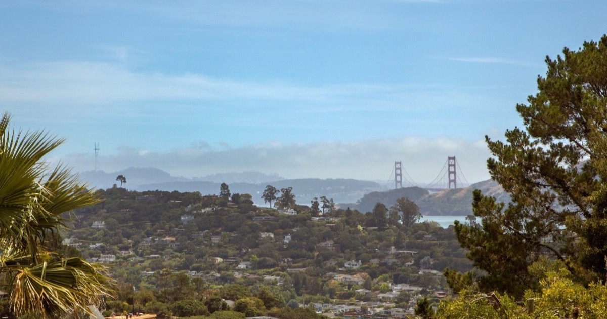
The Golden Gate Bridge view from the gated Tiburon estate Lily currently represents off-market, shown privately by appointment.
Most prominent cities
Tiburon: Lily serves Tiburon and Marin buyers and sellers with the same discipline behind her 104 documented closings and $115M+ in closed volume across the Bay Area. In a thin, high-end market like ZIP 94920, that means parcel-level verification and patient pricing analysis, not guesswork.
Vallejo: largest Solano city, ferry service to San Francisco, Mare Island redevelopment, single-family from the mid 500Ks.
Vacaville: I-80 location between the Bay Area and Sacramento, biotech and outlet retail anchors, single-family from the high 500Ks.
3 cities with dedicated guides
Every city in North Bay has its own advisory page with schools, hospitals, pricing math, and per-city FAQ:
A neutral, side-by-side snapshot of North Bay's cities from the most recent U.S. Census Bureau American Community Survey. Sorted by median home value; every figure is city-wide, and individual neighborhoods and parcels vary.
Source: U.S. Census Bureau, American Community Survey 2019-2023 5-year estimates.
Lily's North Bay track record
2 documented North Bay closings, $0.7M of local volume. Career-wide: 104 documented closings, $115M+ in total volume, with 91 of 104 on the buyer side, 10 closings in the last 12 months, career range $323K to $3.3M, 5.0-star Zillow average across 38+ reviews. Every transaction below links to the address on Zillow.
Call or text me at 415-910-3958 for a free 30-minute North Bay consultation.
104 transactions · $115M+ · 5.0★ Zillow · Cal DRE #02010731
Environment and infrastructure
The environmental and infrastructure factors buyers ask about most, summarized at the regional level. Each factor names the cities in this region that carry the notable exposure; see the individual city guides for parcel-level detail.
Factor
Detail
Gas transmission pipelines
PG&E high-pressure natural-gas transmission lines cross both North Bay cities, generally along the I-80 corridor, and Kinder Morgan SFPP refined-product pipelines also cross Solano County in the Vacaville area; precise alignments near a property should be verified on the PHMSA National Pipeline Mapping System, which excludes local distribution mains. See the individual city guides for parcel-level detail.
Noise (freeway, rail, flight paths)
Traffic noise from I-80 is the shared factor, joined by I-505 in Vacaville (where Travis Air Force Base C-5 and C-17 transport aircraft generate documented overflight noise and Nut Tree Airport adds general-aviation traffic) and by I-780, CA-37, and the downtown ferry terminal in Vallejo; neither city has a major commercial airport directly overhead.
Refineries and heavy industry
Neither city has an oil refinery within its limits, though Vallejo sits across the Carquinez Strait from the Phillips 66 Rodeo refinery (converting to renewable fuels under 'Rodeo Renewed', with recent BAAQMD enforcement) and carries the former Mare Island Naval Shipyard industrial footprint; Vacaville is residential, agricultural, and biotech (the Genentech biologics campus) with no heavy industry.
Soil and groundwater contamination
The dominant site is the former Mare Island Naval Shipyard in Vallejo (operated 1854-1996), a state-lead CERCLA cleanup with the California DTSC and the San Francisco Bay Regional Water Quality Control Board as lead regulators, with documented radiological materials, metals, PCBs, petroleum, VOCs, and unexploded ordnance under continuing institutional controls. Vacaville has no federal Superfund site, only routine smaller cleanup cases. See the individual city guides for parcel-level detail.
Air quality and wildfire smoke
Both cities see regional wildfire smoke in fire season; Vacaville's air quality can see elevated summer ozone from Central Valley-edge heat (the 2020 LNU Lightning Complex fires burned to the city's edge), while Vallejo is generally moderate with bay marine influence plus some refinery and I-80 influence and CalEnviroScreen-flagged pollution burden in parts of the city.
Wildfire zone and power shutoffs (PSPS)
Both cities have CAL FIRE elevated fire-hazard ratings in their surrounding hill and wildland-urban-interface edges and see PG&E Public Safety Power Shutoffs in those outlying areas; Vacaville is the standout, having taken major wildfire impact in the 2020 LNU Lightning Complex fires (which burned into the English Hills area and forced evacuations), while Vallejo's built-out lowland core is far lower-risk. See the individual city guides for parcel-level detail.
High-voltage power lines
Solano County carries major high-voltage electric transmission infrastructure, and PG&E and CAISO corridors and substations pass through both the Vacaville and broader Vallejo areas; proximity to a specific residential parcel should be confirmed against utility/CPUC transmission maps. See the individual city guides for parcel-level detail.
Sea level and shoreline flooding
Exposure is limited to Vallejo's low-lying San Pablo Bay shoreline, the downtown waterfront and ferry area, and especially Mare Island, documented in the Adapting to Rising Tides Vallejo Adaptation Study and Solano County's vulnerability assessment, while its hills are at elevation; inland Vacaville sits at elevation with no direct exposure (its water risk is localized creek and stormwater flooding). See the individual city guides for parcel-level detail.
These are regional summaries from public agencies and are approximate. Pipeline and power-line alignments, contamination parcels, and wildfire zones differ block by block; verify the exact address with the agency tools linked above and your inspections before you write an offer.
Lily's checklist travels north intact: every disclosure read, every claim verified, every carrying cost modeled. What the North Bay adds is terrain and infrastructure. A hillside view lot is only as good as the ground under it, so Lily asks for the geotechnical report (a soils engineer's assessment of slope stability) and inspects retaining walls with the same skepticism she applies to a disclosure packet. In unincorporated pockets, homes often run on septic systems and private wells instead of city sewer and water; both get inspected, and both change the monthly cost model. Fire insurance comes first, not last: across much of Marin, Sonoma, and Solano counties, Lily confirms a property is actually insurable, and at what premium, before her client removes contingencies (the conditions that let a buyer exit the deal with their deposit). And for ferry commuters, the boat schedule is part of the home's value, so she prices it in alongside the square footage.
North Bay FAQ
How do Marin, Sonoma, and Napa compare on insurance availability and non-renewal risk in 2026?
All three counties have FAIR-Plan-dependent pockets where standard carriers refuse. Marin is the most variable: Tiburon and Belvedere are mostly insurable, but specific Mill Valley canyon addresses and Inverness-area hillsides are non-renewed. Sonoma has Santa Rosa and Sebastopol cores that remain insurable while west-county and ridge-road addresses are FAIR Plan only. Napa Valley vineyards, hillside Calistoga, and east-Napa above the floor are heavily impacted. Pull the FAIR Plan quote alongside the standard quote BEFORE removing the inspection contingency; budget $4,000-$12,000+ annually for FAIR-Plan-tier properties.
Is the North Bay still worth it for a commute-to-SF buyer in 2026?
Marin County (Sausalito, Mill Valley, Larkspur) is the only North Bay sub-region with a sub-45-minute commute to downtown SF via the Golden Gate Bridge or ferry. Petaluma and Novato stretch the commute to 60-90 minutes by car; Sonoma, Napa, and Vallejo are 75-120+ minutes. For 3+ days per week in-office in SF, the answer is functionally 'Marin only.' For hybrid 1-2 days, Sonoma and Napa become viable for buyers prioritizing lifestyle over commute.
Wildfire risk by sub-region in the North Bay: how does it actually shake out for insurability?
The CAL FIRE Very High Fire Hazard Severity Zone designation runs through hillside and ridgeline addresses across all three counties. The 2017 Tubbs Fire, 2019 Kincade Fire, and 2020 Glass Fire shaped current carrier underwriting; addresses with prior fire damage or in specific recovery zones face the toughest non-renewal pattern. Defensible space compliance, ember-resistant roofing, and ignition-zone hardening can improve insurability and sometimes negotiate FAIR Plan into standard market. Verify by exact address, not by city; the 1-mile granularity matters.
What's the practical impact of North Bay vineyards and agriculture on residential property?
Vineyards trigger Williamson Act contracts in many cases, which lock the underlying land into agricultural use at a lower property-tax rate but limit subdivision and non-ag conversion. Adjacent residential properties may see grape-spraying, harvest-season truck traffic, and seasonal smoke from cover-crop burns. Buyers should request the Williamson Act status (if any) and the adjacent-parcel use disclosure; this is a Bay-Area-specific factor most generalist agents miss.
Vallejo vs the rest of the North Bay: how does the affordability gap actually play out?
Vallejo single-family entry prices run 40-60% below Marin and 25-40% below Sonoma at the same square footage. The trade-off is mid-tier Vallejo City Unified schools, longer commute times to Marin and SF employers, and a specific 2008-cycle history that affects appraisal comps in certain neighborhoods. Vallejo waterfront (Mare Island area) and St. Vincent's Hill neighborhoods are the best-performing micro-pockets. For buyers prioritizing single-family ownership in the North Bay at any cost, Vallejo is the consistent answer.
North Bay HOAs and CC&Rs: rural and hillside specifics most buyers miss?
North Bay HOAs frequently include shared private-road maintenance fees, well-and-septic shared-system obligations, and view-easement enforcement. CC&Rs may restrict tree cutting, building height, and vacation-rental use (which has tightened across most North Bay cities since 2018). The disclosure packet has specifics most generalist buyer agents skim past; a careful read on the listing side surfaces hidden costs and use restrictions before offer.
How do the Bay Bridge and Golden Gate Bridge commutes change the affordability math for North Bay?
Golden Gate Bridge tolls (currently around $9-$10 each way for cash, $8-$9 FasTrak) plus a 15-45 minute commute from Marin makes the bridge commute one of the more affordable North Bay paths to SF. Bay Bridge from Vallejo via I-80 is $7 FasTrak but adds 30+ minutes from East-Bay-side congestion; ferry from Vallejo to SF Ferry Building is 60 minutes but car-free. The North Bay commute math is fundamentally a commute-mode choice, not a distance choice; the mode determines the affordability picture.
What is the 2026 North Bay price band by county and sub-region?
Marin County is the most expensive North Bay county: Tiburon and Belvedere $3.5M-$10M+, Mill Valley $2.2M-$5M, Larkspur and Corte Madera $2M-$4M, San Rafael $1.5M-$2.5M, Novato $1.2M-$2M. Sonoma County: Healdsburg $1.5M-$3.5M, Sonoma $1.3M-$2.5M, Santa Rosa $850K-$1.4M, Petaluma $1M-$1.8M. Napa County: Yountville and St. Helena $2.5M-$8M, Napa City $1.2M-$2.2M, American Canyon $700K-$1M. Solano County (Vallejo, Vacaville, Fairfield) $500K-$900K. The 2026 spread between Solano single-family and Marin waterfront is roughly 10x, among the widest county-to-county gaps in the Bay Area.
What is the FAIR Plan in California and how do I get a quote?
The California FAIR Plan Association is the state-mandated insurer of last resort for properties standard carriers refuse, primarily wildfire-exposed addresses. FAIR Plan policies are fire-and-extended-coverage only; they do NOT include liability, theft, water damage, or personal property, so most owners stack a Difference-in-Conditions (DIC) wrapper policy on top. Quotes are obtained through any California-licensed broker; expect $4,000-$12,000+ annually for North Bay fire-zone properties plus $1,500-$3,000 for the DIC wrapper. Pull both quotes in parallel during the inspection contingency, not after; carrier acceptance is not guaranteed.
What is the Williamson Act and how does it affect North Bay vineyards and rural parcels?
The Williamson Act (California Land Conservation Act of 1965) lets owners of agricultural land enter a 10-year rolling contract with the county for restricted-use property-tax assessment, typically 25-75% below the otherwise-applicable Prop 13 base. Most North Bay vineyards, ranches, and ag-overlay parcels operate under Williamson Act contracts. Conversion to non-ag use triggers a 12.5% of fair-market-value cancellation fee or a 9-year non-renewal wind-down. Buyers must request Williamson Act status disclosure during inspection; the contract transfers with the parcel and locks the use for the remaining contract term.
What did the 2017 Tubbs Fire, 2019 Kincade Fire, and 2020 Glass Fire do to North Bay insurance markets?
Each fire reshaped carrier underwriting in its impact zone. The 2017 Tubbs Fire burned 36,807 acres in Sonoma and Napa Counties, destroying 5,636 structures (mostly in Coffey Park and Fountaingrove in Santa Rosa). The 2019 Kincade Fire burned 77,758 acres in Sonoma County north of Healdsburg. The 2020 Glass Fire burned 67,484 acres in Napa and Sonoma, devastating St. Helena's east hillsides and east Calistoga. Carrier non-renewal pressure intensified after each event; State Farm, Allstate, and Farmers paused new policies across multiple ZIPs. The 2024 California insurance reforms (Mariposa-rule, FAIR Plan modernization) restored some capacity but not at pre-2017 pricing.
What is defensible space and how do I get a North Bay parcel into compliance?
California Public Resources Code Section 4291 requires 100 feet of defensible space around any structure in a State Responsibility Area or Very High Fire Hazard Severity Zone. Zone 0 (0-5 feet, the ember-resistant zone) requires no combustibles, no woody plants, and metal screening on vents. Zone 1 (5-30 feet) requires limbed-up trees and irrigated landscaping. Zone 2 (30-100 feet) requires reduced fuel and continuity breaks. CAL FIRE and most local fire districts inspect on request and issue compliance letters. Insurers increasingly require compliance before binding; budget $3,000-$15,000 for initial work depending on parcel size.
Where does the Healdsburg, St. Helena, and Calistoga luxury market sit in 2026?
Healdsburg single-family typically runs $1.5M-$3.5M with vineyard-adjacent estates pushing past $8M. St. Helena single-family typically $2.5M-$8M, with east-of-29 vineyard estates running $10M-$30M+. Calistoga single-family $1.5M-$3.5M with hillside post-Glass-Fire stock at sharp discounts on rebuild lots. All three towns sit in CAL FIRE Very High Fire Hazard Severity Zones with FAIR Plan exposure across most parcels. The 2026 market shows compressed days-on-market in the move-in-ready segment and meaningful price discovery in fire-rebuild parcels. Williamson Act and agricultural overlay disclosure conditions every offer.
Why does Marin County price separately from Sonoma despite the proximity?
Marin trades at a 1.5x-2.5x multiple over comparable Sonoma stock primarily because of the Golden Gate Bridge commute. From Tiburon, Mill Valley, Larkspur, or Corte Madera, downtown SF is a 25-45 minute drive or a Larkspur Ferry ride; from Santa Rosa or Healdsburg, SF is 75-90 minutes. Marin schools (Tamalpais Union, Reed Union, Larkspur-Corte Madera, Ross Valley) consistently rank top-decile California. Marin's Mediterranean climate, hillside view stock, and proximity to West Marin recreation drive a different buyer pool than Sonoma's wine-country and town-and-ranch character.
What is the Sausalito and Tiburon waterfront market doing in 2026?
Sausalito waterfront single-family typically $3.5M-$8M with houseboat moorage as a distinct sub-segment ($1.2M-$2.8M for legal liveaboards). Tiburon waterfront $4M-$15M with Belvedere Island parcels at $6M-$30M+. The 2026 market shows strong continued demand at $3M-$5M with longer days-on-market above $8M. Sea-level-rise overlays and shoreline-protection cost disclosure increasingly condition offers; the Marin County Sea Level Rise Vulnerability Assessment maps the impact zones. Many waterfront parcels carry shared dock or seawall maintenance obligations through HOA or private CC&Rs. Verify by parcel during inspection.
How do Marin schools rank by district in 2026?
Reed Union School District (Belvedere-Tiburon area) and Mill Valley School District consistently rank top-5 California with Smarter Balanced scores above the 95th percentile. Ross Valley School District and Larkspur-Corte Madera School District follow closely. Kentfield School District serves a small premium carve-out. Tamalpais Union High School District covers grades 9-12 for most south-Marin students with four comprehensive high schools (Tamalpais, Redwood, Drake, Tam-Marin). San Rafael City Schools serves a larger population with mid-tier outcomes. Novato Unified is mid-tier. Verify exact assignment by parcel through district enrollment offices.
What is the ferry commute from Larkspur, Sausalito, Tiburon, and Vallejo to San Francisco?
Golden Gate Ferry runs Larkspur to Ferry Building in 30 minutes (rush hour every 30 minutes), Sausalito to Ferry Building in 30 minutes, Tiburon to Ferry Building in 30 minutes. San Francisco Bay Ferry (WETA) runs Vallejo to SF Ferry Building or Pier 41 in 60 minutes. Clipper card pricing is $7-$15 per trip depending on route and time. Ferry-walkable addresses in Larkspur, Sausalito, Tiburon, and Vallejo Waterfront / Mare Island carry a measurable resale premium. The 2024 Mare Island redevelopment and Vallejo waterfront promenade extension expanded the Vallejo ferry walkshed.
What is Mare Island's redevelopment status and how does it affect Vallejo housing?
Mare Island was the first US Naval shipyard on the West Coast, operational from 1854 until its 1996 closure under BRAC. Since then, the 5,000-acre island has been redeveloped under master-planner Lennar Mare Island with mixed residential, commercial, and adaptive-reuse of historic shipyard buildings. The 2024-2026 build-out added several hundred residential units. Single-family on Mare Island runs $550K-$900K; mid-rise condos and townhomes $400K-$700K. The Touro University campus and the Vallejo Ferry Terminal anchor demand. Environmental remediation status varies by parcel; review Department of Toxic Substances Control records before offer.
What seismic risk profile does the North Bay carry from the Rodgers Creek and Hayward Fault systems?
The Rodgers Creek Fault runs through Santa Rosa with the 2014 South Napa earthquake (M6.0) reminding the region of inherent risk. The Hayward Fault extends north of San Pablo Bay as the Rodgers Creek system and connects to the Maacama Fault through Healdsburg. The San Andreas Fault runs through West Marin along Tomales Bay. Liquefaction is High in San Rafael bayfront, Mill Valley canyons, San Pablo Bay shoreline, and Vallejo waterfront; Moderate elsewhere. Pre-1980 single-family typically benefits from cripple-wall bracing and sill-plate bolting; CEA Brace+Bolt program covers up to $3,000. Pull the parcel-specific California Geological Survey overlay before offer.
How does the North Bay's Russian-speaking community map across counties?
The North Bay's Russian-speaking community is smaller and more dispersed than the East Bay's, with the largest concentrations in San Rafael, Petaluma, and Santa Rosa (post-Tubbs Fire rebuild-area pockets). Marin's Tiburon and Mill Valley host smaller Russian-speaking professional populations associated with biotech and finance. Lily Garipova represents Russian-speaking buyers and sellers across the North Bay with full California disclosure review in Russian (Transfer Disclosure Statement, Natural Hazard Disclosure, Seller Property Questionnaire, FAIR Plan and DIC quote analysis, Williamson Act status review). The English documents remain legally binding.
What is the North Bay short-term-rental and vacation-rental regulatory landscape in 2026?
Napa County limits short-term rentals (under 30 days) to permitted properties in specific zones with a citywide cap. Sonoma County permits STRs in unincorporated areas under a vacation-rental certificate program with periodic moratoriums. The City of Sonoma maintains a 4% cap on STR licenses with a waitlist. Healdsburg, Sebastopol, and Santa Rosa each have distinct STR ordinances. Marin County's coastal-zone STRs require a Coastal Permit. Buyers planning STR income must verify by parcel that an existing permit transfers or that one is available; many parcels are STR-ineligible regardless of zoning, especially in HOA-governed subdivisions.
What is well-and-septic ownership and what should North Bay rural buyers verify?
Many North Bay rural and hillside parcels run on private well water and septic systems rather than municipal hookup. Wells require periodic water-quality testing (bacterial, nitrate, arsenic, manganese); county-recorded production rates may be outdated. Septic systems require periodic pumping, inspection, and sometimes Onsite Wastewater Treatment System permits depending on soil class. Sonoma and Napa Counties require septic inspection and certification at sale. Shared wells and shared septic across multiple parcels carry CC&R obligations that transfer with title. Always pull well-and-septic disclosure and certification during inspection contingency.
How does the Travis Air Force Base buyer profile shape Solano County housing?
Travis Air Force Base in Fairfield is Solano County's largest single employer with 14,000+ military and civilian personnel and over $1B in annual local economic impact. Active-duty buyers use VA loans extensively, which simplifies entry but carries termite-clearance and roof-condition requirements that condition offer negotiations. PCS (Permanent Change of Station) cycles every 2-4 years create a steady listing supply; many Travis-area listings are time-pressured. Vacaville, Suisun City, and Fairfield carry the most concentrated demand from Travis personnel. The Travis buyer profile keeps Solano single-family liquid at the $500K-$800K band even when broader Bay Area volume slows.
What is the Genentech Vacaville campus and how does it shape Solano demand?
Genentech operates one of its largest biologics manufacturing campuses in Vacaville with several thousand employees. The Vacaville campus produces a meaningful share of Genentech's global commercial product. The biotech-employee population drives a different Solano buyer profile than the military and logistics segments: typically higher cash comp, less RSU exposure than tech, longer commute tolerance, and preference for newer construction in Vanden Meadows, Browns Valley, and the Vacaville hills. Single-family in the Vacaville biotech-favored neighborhoods typically $700K-$1.1M, condos and townhomes $400K-$650K.
How does Lily Garipova represent North Bay buyers specifically?
Lily reads every disclosure end-to-end (TDS, NHD, SPQ, HOA package, preliminary title), pulls the parcel-specific FEMA, CAL FIRE FHSZ, and Alquist-Priolo overlays, requests FAIR Plan and DIC wrapper quotes during inspection contingency for any fire-zone exposure, verifies Williamson Act status for any rural or vineyard-adjacent parcel, models full carrying cost including the county-specific property tax rate plus any special assessments, walks the property at multiple times of day, verifies the school assignment with the district registrar by parcel, and stays willing to recommend walking from a deal that does not pencil.
How does Lily Garipova represent North Bay sellers specifically?
Strategic Listing Model applied at the North Bay sub-region level: comp set drawn from the exact sub-region (Coffey Park rebuild vs original-Coffey, Tiburon waterfront vs interior, St. Helena hillside vs valley floor), not county-wide averages; pre-listing inspection including defensible-space audit, septic-system certification, and FAIR Plan insurability check; professional staging targeted to the sub-region's actual buyer pool; full Williamson Act and shared-well/septic disclosure preparation; multi-platform marketing with active bid management. 2 documented North Bay closings, $0.7M local volume in Vallejo and Vacaville.
What are Lily's documented North Bay transactions?
Lily Garipova has 2 documented North Bay closings on approximately $0.7M of local volume across 2 cities in Solano County: 113 Martin St in Vallejo ($0.32M, Mar 2019, buyer-side) and 719 Greenhaven Dr in Vacaville ($0.42M, Nov 2018, buyer-side). Marin, Sonoma, and Napa County coverage is supported through Lily's broader Bay Area practice. Career-wide: 104 documented closings, $115M+ total volume, 91 of 104 buyer-side, closings in every year since 2017, 5.0-star Zillow across 38+ verified reviews.
How do I schedule a North Bay consultation with Lily Garipova?
Call or text 415-910-3958, or email lilyagaripova@gmail.com. Free 30-minute initial consultation by phone, Zoom, or in person at any North Bay address that works for you. Available in English and Russian. Cal DRE #02010731. The consultation walks through your specific buying or selling math: budget, timeline, fire-zone and FAIR Plan exposure, Williamson Act and well-and-septic considerations, school constraints, bridge-vs-ferry commute, financing pre-approval, and the realistic North Bay sub-region that fits.
What is SMART rail and how does it serve Sonoma and Marin commuters?
Sonoma-Marin Area Rail Transit (SMART) runs a 45-mile commuter rail line from Larkspur to Cloverdale through San Rafael, Novato, Petaluma, Rohnert Park, Santa Rosa, and Healdsburg. The Larkspur terminus connects to Golden Gate Ferry for the SF Ferry Building leg. End-to-end Cloverdale-to-SF via SMART plus ferry runs about 2 hours 45 minutes. Walkable-to-station addresses in Petaluma, Santa Rosa Downtown, and the San Rafael Civic Center area carry a modest resale premium. The 2026 service runs 38 weekday trips with hourly off-peak headway.
How does the 2014 South Napa earthquake affect 2026 Napa property condition diligence?
The August 24, 2014 South Napa earthquake (M6.0) on the West Napa Fault damaged or destroyed thousands of structures in downtown Napa, American Canyon, and Vallejo. Most major damage has been repaired but specific buildings still carry seismic-retrofit obligations, and the 2014 event reset insurance underwriting in the impact zone. Buyers of pre-2014 Napa County stock should request repair permit history, post-2014 engineering inspection records, and the parcel-specific California Geological Survey overlay before contingency removal. Many downtown Napa adaptive-reuse projects (Oxbow Public Market expansion, First Street rebuild) date from the post-quake recovery period.
Free 30-minute consultation to walk through your North Bay buying or selling math in either Russian or English. Call 415-910-3958 or email lilyagaripova@gmail.com.